Saturday, November 5, 2011

Northshore Peak

With the colder weather sweeping through the Vegas area, Mt. Charleston isn't really much of a hiking option anymore.  There is probably snow on every peak we'd want to hike to, and we don't have crampons/ice axes/snowshoes to get up there.  Red Rock is a decent option in the winter, but the area can still receive snow and actually, this particular weekend, there was snow at the top of Bridge Mountain, which is where I wanted to hike.  That leaves the Lake Mead area, which is kind of an unknown for Karen and I.  I've been boating there a few times, and Karen ran a half marathon out there, but I had no idea how many name and unnamed peaks are in this massive area, awaiting exploration.

We decided to do the 3 mile route to Northshore Peak, since we had a time constraint.  There's no trail to the top, but it's an easy to follow route.  The route starts at a rest area about 18 miles down Northshore Road.  You basically park, take a look at the peak, cross the street, and start walking towards the saddle just to the east of the summit ridge.

Temps were wonderful, probably in the mid-50's.  I had just scored a nice new long sleeve moisture wicking shirt and got to try it out.  It worked well.  It was mildly breezy but nothing to impede our progress.  We quickly made it to the base of the saddle, but at this point you're looking up at a wall and you need to find a way around it to gain the saddle.  We found a chute just to the left (east) and picked our way up on to the saddle.  From here, we just followed the ridge.  We had momentary flashbacks to Bear Mountain in Sedona, with its numerous false summits.  Each time we'd gain a high point on a ridge, there'd be more to the hike remaining.

Just before the final couple hundred yards to the summit, there's a downclimb that's necessary to get around a small crevasse in the ridge.  We analyzed our route before making our way down and then back up, and in a couple minutes, we reached the summit.

The views are very nice from the top.  We had fun pointing out Potosi and the Spring Mountains to the West, the Sheep range to the Northwest, and the Muddy Mountains and Bowl of Fire to the North.  Virgin Peak (with snow on it) was to the Northeast, and then we could spin around and see Lake Mead to the South.  The sun finally peaked out just as we reached the top and it warmed us up enough to keep us comfortable up there.  Karen brought some raspberries and we sat happily munching them, enjoying the view.

We found the summit log, which was actually a piece of paper in a glass jar.  Unfortunately, there was no pen/pencil to sign with, so we weren't able to sign.  That's a bit of a bummer, since it looks like only a few people a year get up to Northshore Peak.  We saw signatures on the single piece of paper from back in 2004.

Unfortunately, we needed to get back.  Had we not had the time constraint, we would have continued West along the ridge.  It was a little thin and looked fun.  Alas, we retraced our steps and made our way back to our car.

It's a bit of a long drive out that far on Northshore Rd. but we learned that the Lake Mead area is HUGE and I can't wait to get out and explore more of it.


Sunday, October 2, 2011

Mummy's Tummy - Summit

This was our third attempt at Mummy Mountain and we completed the hike this time in about 5 hours and 15 minutes total.  You can read about our other attempts here and here.  By this time Karen and I were more than ready to complete the hike, and it looked promising since the weather was clear and warm.  We purposely checked the weather and avoided Saturday, since rain was predicted.  It was a good call on our part as it did rain in the Spring Mountains on Saturday.

When we started the hike, we both noticed that we weren't feeling as robust as last time.  My legs just felt sluggish, so we assumed we were on a slower pace (not that we are speed hikers).  However, we reached the junction of North Loop and Trail Canyon on almost the same schedule as last time.  A bonus is that I was able to take some photos along the way.  The colors are definitely changing in the Spring Mountains, and I was happy with the photos I was able to get as fall began to set in.

After the junction, our sluggishness remained but our enthusiasm was unabated.  I snapped a few more photos just before Cave Springs and we reached the infamous scree slope fairly quickly.  Other than the soggy, frustrating attempt last time, this was our first shot at the slope and I have to say, it took a lot more out of us than we expected.  We rested fairly frequently and it took us about 35 minutes to reach the top.  Halfway up, we adapted the "duck walk" that climbers on Everest are famous for using in order to ascend.

After the slope, the summit looked so far away and our legs ached from the challenge of the scree.  However, it felt really good finally have reached a point in the hike we hadn't previously.  We pushed on along the ridge toward the summit cliffs.  The path was easy to follow and it was moderately uphill. Our final challenge was a relatively safe scramble through a little chute in the summit cliffs.  The rocks there were very sharp and loose, but care won the day and as we climbed, we saw more and more of the clear blue sky revealed to us.

Reaching the top was a great feeling for us both.  Of course, the view was great, but we both reveled in the feeling of an accomplishment that was three attempts in the making.  It made getting lost the first time and rained out the second time worth it.  Our peanut butter and jelly sandwiches tasted superb and we smiled as we ate and enjoyed our time at the top of the 2nd highest peak in the Spring Mountains.

The summit is very large and broad and not a soul was up there.  According to the summit log there were about 20 groups from the month of September, and most were doing the "trifecta" (Griffith, Charleston, Mummy).  The last logged summit was 3 days before ours.  We took some photos and explored the area.  Now that I have been to the top of Mummy and Lee, I would say that Lee's views are much more impressive.  Mummy's views are far reaching being at 11,500 feet, but many trees prevent a true panoramic view.  Our total elevation gain in the 8.5 mile trek was about 3,700 feet.

Our hike back was quick and largely uneventful.  We descended the scree slope in under 15 minutes and drank in the site of the setting sun over the valley.  The backlit autumn leaves seemed to glow in the golden sunlight, and we couldn't help but feel the whole scene was our reward for a job well done.


Saturday, September 10, 2011

Attempt 2 - Mummy Mountain, Mt. Charleston

Sadly, I will just start out by saying, there is going to be an attempt 3.  You can read attemp 1 here.  You are reading this from two very sad hikers who were more than up to the Mummy Mountain challenge this time, but mother nature had other plans.  We will try to keep this as upbeat as possible, but we are both very frustrated that we are going to have to dedicate yet another weekend to trying to reach the Mummy Mountain Summit.  It's not that we don't enjoy the hike, but it's very disappointing because we have lots of other peaks in our area we want to hike, and even more outside of the city.  Unfortunately, Karen works 2 weekends of the month.  Now that we have upped our difficulty to 10 mile hikes, it is hard for us to do two hikes on the Saturday and Sunday back to back and so we will have spent 6 total weeks waiting to conquer Mummy Mountain.  If you knew our conquering personalities, this is a bitter wait as you can see the full Mummy from Las Vegas.  Phil looks at it all the time with a sigh.

Anyways, back to describing our adventure.  Just as our blog is named, Phil and Karen had quite an adventure on this hike.  We started at the same trail head, Trail Canyon, and parked in the lot off of Echo Canyon Road.  This time it was much much cooler at the start of the hike.  It was only 67 degrees to start, compared to the 80's we started in last time.  It was only 52 degrees at our car when we finished.  We made very quick work of the first 2 miles to get to the North Loop Trail junction.  It took us about an hour and we weren't too winded at all.  At the North Loop Junction, we began to notice the rain we had seen to the south was moving more towards our direction.  We powered along, past the man-made water trough called Cave Spring, and did almost a horseshoe from the North Trail Junction.  We reached our next destination- the scree slope in only about 45 more minutes.

At the scree slope is when the heavier rain had started to fall.  About a mile before the scree slope, we passed a bunch of hikers putting on their ponchos.  Sadly, we didn't have any ponchos.  We had an emergency heat blanket, a signaling mirror, and a hodge podge first aid kit, but no ponchos.  At the bottom of the scree slope you are about 3 to 3.3 miles into the hike and we had a decision to make.  It's probably about another mile to the summit, but a large climb  (We don't know exactly how long to the summit since we are still waiting for our next opportunity).  Neither of us wanted to decide to turn back so we continued and tried to climb the scree slope.  During the climb, the rain got heavier and heavier and we became very cold, as our poncho-less clothing got soaked.  A little over half way up the scree, we decided to go under a thick tree and see if the rain would pass.  We whipped out the emergency heat blanket, but it was pretty much useless.  The wind blew it around and blew under the thin Mylar type sheet.  It was advertised as a two person blanket, but we were so cold, lacked dexterity, and were fighting with the wind, so we couldn't quite make it fully cover us both.  We were semi warm where our shoulders touched and that was it.

Under the tree is when we realized we couldn't continue.  Not only were we already freezing cold, but we had at least 500 ft to gain in elevation and would only be getting colder.  We were also looking straight out over Mt. Charleston and saw nothing but rain and dark clouds.  Even the close peak off of the Trail Canyon hike was fogged by rain and barely visible.  We saw nothing but having to go down the rest of the hike in pouring rain, so we decided we can not continue up another mile, and then down 4.5-5 miles in soaking rain and so we descended the scree slope.  Descending was tricky because all the trees on the ground were wet and slick as ice.  At this point, the prepared hikers with the ponchos had caught up to the bottom of the scree and they were going to be turning back as well.  They were relieved when we said we were also calling it a day.

Soaking wet and freezing, we decided we may as well run down as far as we could to decrease our time in the storm.  It was a brand new experience for both of us, running down a mountain with your pants stuck to your legs, your shoes soaking wet, soggy, and loose, and trying not to trip and break your arm.  We also had very heavy packs on since 3L each of water was unnecessary with the colder weather.  Being soaking wet and miserable, it didn't cross our minds to dump some of the superfluous water until well over a mile into running.  We ran just past the junction to get to the trail canyon trail. At that point, Karen tripped on a rock and narrowly avoided falling (she kept getting pebbles in her shoes.)  Phil also insisted that running was colder than walking due to the wind it caused, so we walked the rest of the way down dripping wet. 

The only pictures we got were near the time when we decided to start walking down instead of running.  It was only a light sprinkle so Phil braved it with his brand new camera and got a few good shots of the storm, and a few of our soaking wet selves.  His hands were so cold he could barely get his camera out of the bag because his thumbs and fingers lacked all dexterity.  We also got a few shots with an iPhone when we were hiding under the tree on the scree slope.  I guess better than last time when we got lost and didn't bother to take any pictures.

As we finished the last mile down, the rain really picked up again and the thunder started.  Not that we wanted to get any wetter, but it did make us feel better about abandoning the hike, at least the weather was still crappy and we didn't turn back for nothing.  It was the safe thing to not continue, but it wasn't what we wanted to do at all.  Finishing the hike, we were pretty down and had to remind ourselves we still completed an almost 7 mile hike, climbed 3,000 feet and made amazing time to the scree.  We also started earlier than usual and got to say "Good Morning" to the other hikers without any pause or hesitation, unlike our usual starting time.  We both know that our hiking conditioning has increased significantly by the ease that we hiked today and think that next time we will definitely bag Mummy's Tummy.


Link to GPX: https://www.dropbox.com/s/1s2zvnb4fyauzqo/Mummy%20rainout%20GPX.gpx

Saturday, September 3, 2011

Lee Peak - Mt. Charleston Phil and Adam

Lee Peak is a hike I've been wanting to do for awhile.  The route I decided to take is a shortcut through the Las Vegas Ski and Snowboard Resort.  Since I've ridden my board there several times in the winter, I thought it'd be fun to visit in the summer.

You climb over 3000 feet in roughly 1.5-2 miles, so I knew it'd be a tough uphill hike.  I also decided it'd be a good opportunity to try out some night/early morning hiking, so I planned to start hiking early in the morning with my buddy to make the summit by sunrise.  Then I'd be able to take some amazing photos.

Unfortunately, our "sunrise summit bid" was flawed from the get go.  I didn't budget enough time for the drive, I didn't budget enough time for the hike, and I woke up late.  We hit the trail at about 5:45, and the sky was already starting to brighten with the rising sun.

The first part of the hike takes you right up the ski run called "The Line" which follows the main chairlift.  At the top, you veer left and enter a dirt road just before the ski patrol shack.  The road leads to a wash, which you follow up.  At this point, if you look to the southwest you should be able to see Lee Peak, the most prominent peak on the ridge.  You know you're going the right way when you encounter a small waterfall with water draining into a pipe.  From here, you can pretty much see what you need to do;  find a way up to the ridge.  This is when the easy hiking ends.  When we ascended, we simply followed the stream as it went up the mountain, always keeping the ridge in view and moving right (West) whenever possible.  There is a lot scrambling up boulders, small waterfalls, and fallen trees as you follow the stream.  Later, about 40%-50% to the ridge, it becomes a scramble up loose scree and gravel.  The bear crawl will be very useful.  The grade here is very steep and we had to rest frequently.  Slowly but surely, though, the ridge will come into view and you'll reach the top.  At this point, according to my Garmin, we were 1.3 miles into the hike.

Since there aren't a ton of detailed descriptions of this particular route, we had to make some decisions on our own.  Specifically, once at the ridge, we were afraid the North Loop trail would descend too far down the other side of the ridge and we'd miss the summit of Lee, so we decided to make our own trail, staying as high on the ridge as possible.  This worked, but it made for some very sketchy boulder climbs with some scary exposure.  At a couple points we were forced to retreat and find a longer way around the scariest stuff.  One particularly nervewracking climb put us at the top of a broad, flat peak with a wind measuring instrument on it.  There was no label anywhere on it so I don't know if this peak is named.  This was the final peak before Lee.

We reached the 11,300 foot summit of Lee Peak 1 hour 50 minutes into our hike at a distance of 1.93 miles.  The 360 degree views from the summit are very nice, and even though the day was very hazy, we could see all the way to Lake Mead.  Pahrump was clearly visible to the West.  Also, there were nice, closeup views of Charleston Peak and Mummy Mountain in all its glory.  We spent about a half hour on the summit eating and taking photos, then we started back down.

We decided to try and take as much of the North Loop as possible back to the ridge, since we didn't want to repeat some of the climbing we had to do on the ridge.  Just after starting our descent, however, I slipped when climbing down a rock.  My shoulder instantly dislocated (this happens to me a lot) and I fell on some sharp rocks.  I had to calmly take my backpack off, raise my dislocated arm up with my good arm, and let the joint fall back into place.  It was immediate relief from the pain, but I knew the joint would be tender and delicate the rest of the way down.  I also ended up skinning my knees and elbow up pretty bad on that fall.

Following the North Loop back to the ridge worked really well for us.  It was much quicker and safer.  Once on the ridge, we assessed our line of descent and tried a slightly different one that seemed safer.  We sideways-slid our way down the scree until we came to the wash, then picked our way through the fallen trees and sticker plants until we reached the road.  From there it was an easy descent through the resort to our car.  Total distance was 3.9 miles, elevation gain/loss was 3,219 feet, total time was 4 hours.

So if you're planning to do this hike, here are some quick tips:
  • plan on the hike being very strenuous (the Summitpost.org posting for the hike glosses over this a bit)
  • plan on there being no defined path for the majority of the hike
  • bring some gloves if you don't want your hands to be nicked up by stickers plants, brambles, and sharp rocks
  • once you gain the ridge, proceed to the North Loop trail just on the other side.  Follow it to Lee Peak.  Don't make your own path on the ridge
  • especially on the descent, plan on your shoes being full of pebbles and dirt, unless you wear pants
Most people don't set out to hike only Lee Peak, they make Lee a short excursion off of another route.  However, if I were to return to Lee Peak, I'd think about taking the North Loop trail there.  It'd be longer, but the North Loop is a beautiful trail and it'd be a lot less strenuous.  Also, this route could serve as a shortcut to Charleston Peak.  Perhaps for another time...


The view over Lee Canyon from Lee Peak.  I believe the Sheep mountain range is in the distance.


Pahrump from Lee Peak

Charleston Peak from Lee Peak

The way we came.  We picked our way along the ridge over the nearest two humps.

Victorious


Lee Canyon

The wash below the slope up to the ridge is full of debris.


Partial GPX link as the battery failed: https://www.dropbox.com/s/ny4cs56b5reg4pu/Lee%20Peak%20Adam%20GPX.gpx

Saturday, August 27, 2011

First Attempt - Mummy Mountain Tummy Route

We have wanted to conquer Mummy Mountain for quite some time since it's one of the most prominent peaks you can see from the Las Vegas Valley.  Since the hike is quite challenging and a long distance, we have slowly built up our hiking skills and decided on this fine weekend we were finally ready for the adventure.

We are not morning hikers and often pass many people coming down from a summit as we are just starting our journey up.  Our journey this morning began just before 11am and it was sweltering hot down at the start.  We parked at the Trail Canyon Trailhead off of Echo Road.  Our beginning ascent was very sweaty and hot, but every now and then we would get a breeze and get the motivation to keep plugging along.  Less than a mile in, Karen had to stop and attend to a beginning blister, but she was fully prepared with a package of moleskin.  Our feet both got a few wounds by the end.

Since we had wanted to do this hike for quite a while, we had several sources to guide us along the way.  Our primary reference was Afoot and Afield: Las Vegas and Southern Nevada: A Comprehensive Hiking Guide by Brian Beffort, a new hiking book Phil got for his birthday.  We also had a general hike printout from http://www.birdandhike.com/Hike/Mt_Char/Mummy_E/_Mummy_E.htm , which we figured out on the trail was to get to Mummy Mountain from the raintree hike (we previously hiked Raintree here), so that guide had to be abandoned since we started elsewhere.  Finally, we had a topographic map of the Spring Mountains, a hardy and waterproof map Karen picked up from REI.  Surprisingly, the topographic map did not have the trail marked to get to Mummy Mountain.

We reached our first turn onto the North Trail headed towards Charleston Peak at about 1.6 miles according to our GPS.  This is when our doubts about the GPS began since the book we were using for directions stated we would reach it at 2 miles, but we continued on the North Trail and our next landmark was to be Cave Springs.  We passed several hikers coming down and were warned about some red Star Nursery Flags a ways up.  The red flags left us puzzled because when you looked to the right, there was nothing but a huge cliff, so we decided this could not possibly be the scree we needed and carried on looking for the Cave Spring (which was in the book and on the topographic map).

We had several mishaps, but not finding Cave Spring had to be one of the main things that led us astray.  Along our journey, just past the red flags, we passed a water trough with a pipe.  We never in a million years thought this man-made water trough could actually be Cave Spring.  Later, after researching more, that water trough was Cave Spring.  Silly that it would be on the map as a spring, and even more silly that the book wouldn't point out that Cave Spring was actually a little man-made watering hole. 

Not finding Cave Spring really set us back, but we carried on along the North Trail.  After quite a while, we passed a hiker coming down who was really nice and she indicated that we had a few more switchbacks and we would reach the scree.  She was really nice, but this is another point we were led astray.  She also gestered up towards Charleston Peak as where we would find the scree and somewhat led us to believe we had quite a ways to go to get there.  So we kept on going and going and going.  Karen took a short break to eat some granola not long after we passed this hiker.  This is funny, and you will see why later!

After lots and lots of switchbacks and many miles, we came upon a scree!!  During all those miles we kept referencing our book.  We probably took it out of the backpack no less than 10 times and we kept saying to ourselves, does this look like a stand of dead trees just past a limestone cliff to the east??  That's how the book described where we would find the scree to ascend to the mummy's tummy.  Unfortunately for us, there are stands of dead trees and limestone cliffs EVERYWHERE along the North Trail.  So each of the 10 times we pulled out the book, we kept wondering which could possibly be the right stand of dead trees!!!  We even questioned how many miles it was taking us to get to the magical stand of dead trees, but since our GPS gave us a mismatched mileage earlier, we ignored it. 

So finally, we get to a scree.  And it is so easy!  Easiest scree compared to what we had read about a dreadful scree on this blog.  So we had doubts about the effortlessness with which we climbed this baby scree that we'd heard dreadful things about.  We climbed it in about 2 minutes (big warning sign) and we just keep on walking along until we come upon a precipitation guage from the USGS and think, hmmm, have we made it???  There was an ammo box with a log in it that a few other people had signed, but it was like less than 20 people in a year.  Most of the people that had signed the log were either a part of the USGS inspecting/checking on the precipitation guage or hikers that mentioned heading on to Charleston Peak or Mummy Mountain.  BAD sign since we had hiked and hiked and thought we had reached the mummy's tummy.

We carried on along the ridge, did some scrambling and had faint hope we could take this ridge to the tummy.  Needless to say, it was a no go.  Phil and I did some dangerous scrambling up and down the sharpest rocks trying to salvage our way to our destination.  After a while, we finally got to a point where we could see a brown slope that was obvisouly the actuall scree up the our intended destination, it was no joke of a scree.  We were already at the top of the scree, but there was a huge hike ahead to get to the top of the tummy. We stat down defeated.  We had been hiking over 4 hours and what lied ahead to salvage our mission was just too much.  We didn't have enough food or water (we carried 3 liters each already) to hike for 10 hours, we didn't have enough energy to make a 12-13 mile hike and there were ominous storm clouds all over Mt Charleston, but lots above Mummy Mountain.

Running through both our minds was if we should continue on or go back.  We reached the same decision silently and decided to eat our PB&Js and then make our journey down.  The journey down was full of sliding through loose rocks and mountain debree along an angle to get to the real scree so that we could find our way back without doing the extra miles that we had taken to get to where we were.  Our ankles were screaming by the time we got to real trail to descend. 

This is probably the saddest part of the whole journey.  At the bottom of the real scree, we came across a marker that should have been a dead giveaway to mark our scree for ascencion.  A giant dead tree with an M carved into it and an arrow pointing up!!!  Why did the book not say this??  Why did the hiker not say this??  And ironiclly, it was literally 200 feet from where Karen had stopped to eat her granola earlier!

Not too much more to the story, except that we hiked down with aching knees, aching ankles, aching backs, and a bit of a defeated feeling since we didn't "bag the peak" (as Phil would joke).  The weather was much cooler along our hike up and hike down and the rain that started really felt great.  We got to finsh our hike with thunder sounds in the moutain, the smell of rain that reminded us of our dear Allegany, and cool rain drops on our hot skin.

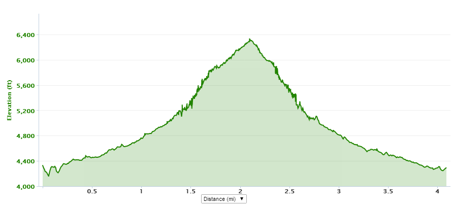
While we didn't get to the mummy's tummy, we did hike 8.5 miles for 6 hours and we did climb 3100 feet, which is by far our longest hiking acomplishment thus far.  We also have a thirst to go back and really bag the tummy.

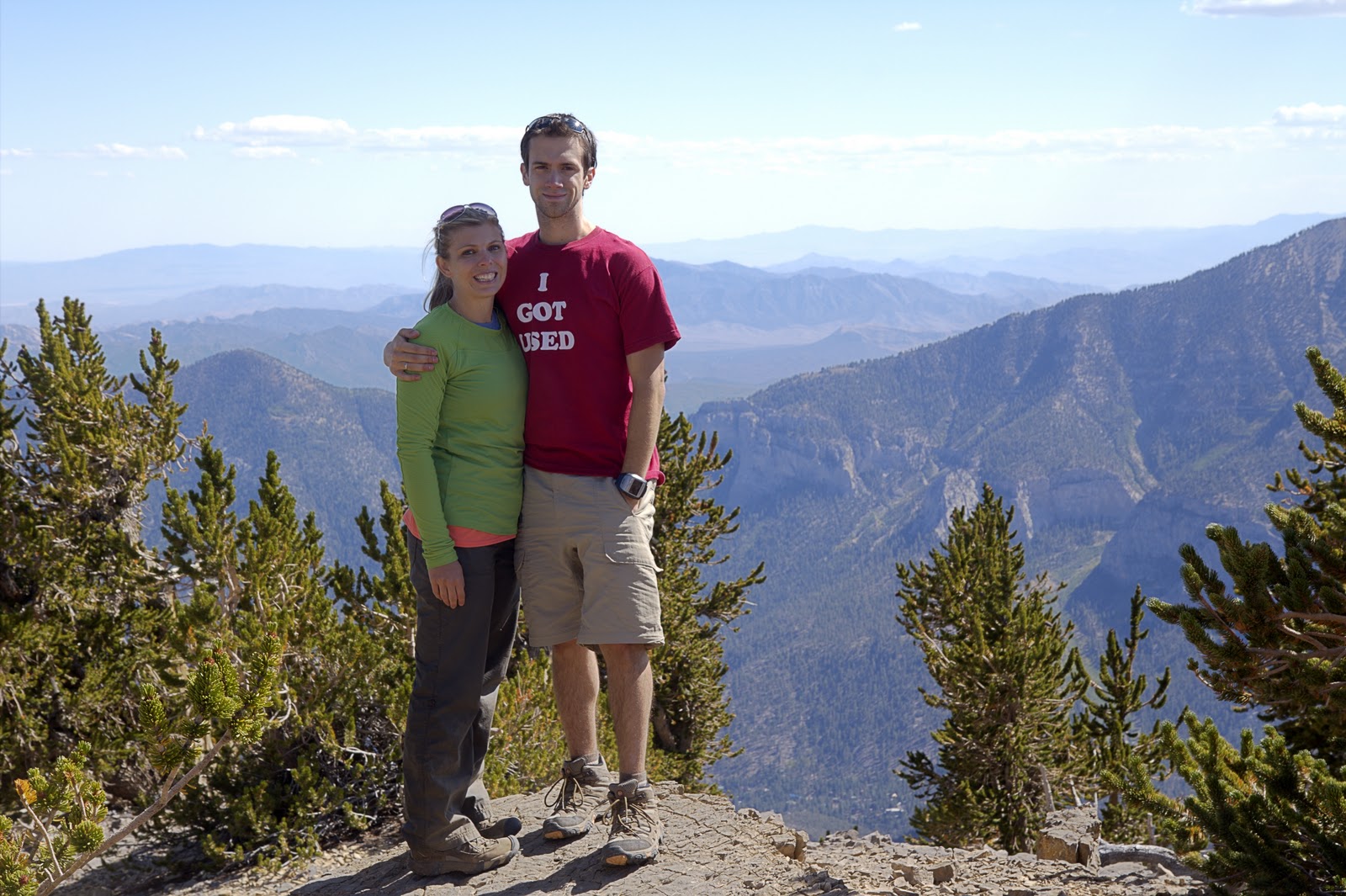
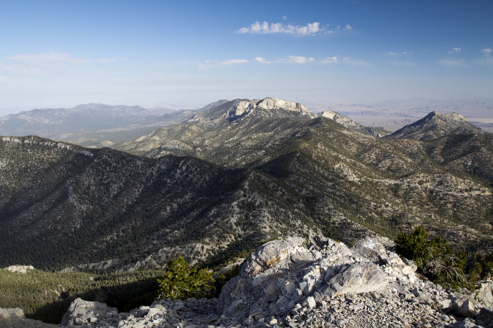
We were too depressed about not making the peak to take our own pictures, so you will have to wait until we actually make it to the Mummy's Tummy for some of our views.

Our GPS battery died so we do not have the complete GPX, but here is the link to the partial GPX of our failed summit:  https://www.dropbox.com/s/yht1i0ninh75tak/Mummy%20failed%20GPX.gpx

Saturday, August 13, 2011

Bear Mountain - Sedona, Arizona

Coming Soon


Sunday, July 3, 2011

Raintree - Mt. Charleston with P&K, Stina, and Alex

The Raintree hike takes you to what is thought to be a 3,000 year old Bristlecone tree and is a nice moderately strenuous trek at high altitude.  We did this with a couple of friends and we all remarked about the higher altitude making us short of breath, but this was mostly in the beginning of the hike.  We either acclimated or stopped noticing towards the end of the hike to the Bristlecone tree.  Some of us had recently lost weight and that was apparent with how much easier hiking was on this day.

We started at the Deer Creek Trail Head and returned to the same place, but you can actually finish at the Trail Canyon Trail Head if you had two cars.  The hike is about 2.7 miles one way and you gain about 1500 feet, so it's a pretty good, moderate hike, but the altitude may push it it into strenuous territory for some.  If you continue on for about 1/3 mile after the raintree, you will get to Mummy Springs, although we did not do that this time.  Next time we will definitely go to Mummy Springs, most likely in the spring because you can see all kinds of wild flowers early in the year.  You may also see deer and other animals watering at the spring if you sit very quiet in the early morning.

On the Raintree hike, there are great views of other mountain ranges and you can see the Mummy's toe from the raintree stopping point (see picture below).  We enjoyed some apples at the top and descended pretty quickly after.  Being pressed for time, we did a lot of running down the trail and the altitude was surprisingly not too challenging running down.  We finished the hike in about 2 and 1/2 hours and would say it was enjoyable for sure and a great way to get a break from the Las Vegas heat.


Mummy's Toe is in the background towards the end of the hike
The group with the ancient Bristlecone Tree

Sign where you turn around or head to another trail

Mummy's Toe

Saturday, June 18, 2011

Black Mountain - Henderson, NV

Black Mountain is a unique hike because the trailhead is literally right within suburbia.  Fortunately for Karen and I, it's also only a couple miles from our house.  Black Mountain is a prominent peak in Henderson and it's one you can see from anywhere in southern Las Vegas.  I see it every day on my commute and I figured it'd be nice to be able to say I'd been at the top.

I had heard mixed reviews of the "official" trailhead that most hikers use, so I just used Google Maps to find a side street in a neighborhood at the base of the mountain.  We were able to park without obstructing anyone's driveway so I figured we'd be okay.  From there I had already planned ahead and brought a map to figure out how to cover the .4 miles to get to the start of the trail.

The trail itself is very well marked the entire way up and only gets difficult toward the top.  There is some light climbing up large rocks toward the top of the mountain that is reminiscent of the harder parts of Turtlehead Peak.

The views from the top are panoramic and very good.  The city sprawls in front of you to the northwest and west.  In the distance you can see Potosi and the Spring Mountains.  Lake Mead and Boulder City are visible to the East.  The only drawback we found to the summit were the small black flies that were constantly swarming us.  Strangely, as soon as we left the summit, there were a non-factor, but on top they were brutal.  There is an American flag up there, and also a geodetic survey marker. 

Black Mountain is a fairly easy hike that starts virtually inside Henderson.  It has a lot of potential for unique hiking trips, i.e. sunrise/sunset hikes or bike/hike trips.  The well-marked trail would present few problems in the dark with headlamps and we are excited to see what the views will look like with a sunrise/sunset backdrop.


Black Mountain vista by philskaren

Black Mountain Vegas by philskaren

Summit looking northeast by philskaren

Geodetic survey marker by philskaren


Link to GPX: https://www.dropbox.com/s/2cidzp22w00xzey/black%20mtn%20GPX.gpx

Saturday, June 11, 2011

Turtlehead Peak - Red Rock, NV

Phil and I have actually climbed Turtlehead Peak 4 times.  We've made it to the top all but once.  It is a hike that we enjoy the challenge of time and again.  Some people say I'll never do that hike again or quit before reaching the final summit, but they are really missing out.  There are many different conditions you can do this Red Rock hike under, so more than once is highly recommended.  We have hiked it in the absolute heat of summer and in January.

The first time we went on this hike was in the spring or summer of 2006 with two guys Karen knew from school.  These weren't couch potato guys by any means and we tagged along not really knowing what we had gotten into.  When we got to the trail head they pointed several times to the actual top of Turtlehead and said that was where we were going, but neither of us really believed them.  Honestly, we were at the ridge just under the top of the head when we actually believed we were going to the peak they had first pointed out to us.  At this ridge was where we decided we weren't going any further.  We waited there for them.  Now, this may seem wimpy that we bailed early, but these guys were in much better shape than us and we had no idea what we got ourselves into.  For example, after doing the hardest climb Phil and I had ever been on, the four of us ran down several miles.  They were unfazed and we had a new goal- to get to the top of Turtlehead Peak, but maybe at a slower pace.  This may have been the start of our conquerer's bug, who knows?


The 2nd time we did Turtlehead Peak, we took some family with us.  I think we had a group of 5 people.  It was in March (2007), but it was actually a hot hike.  This time Phil and I knew that we would not stop early and we must go to the top.  I think that we left a few of our party back at the ridge on this hike.  My memory is fuzzy who didn't make it to the top, but I do know that Phil and I 100% made it to the top of Turtlehead this time and it was so worth it.  The views of Las Vegas are stunning.  You can actually make out many prominent casinos in the valley.  The sense of accomplishment was incomparable for us, this was truly one of the first hard peaks we had ever conquered.


The 3rd time we hiked Turtlehead was during the winter in January (2008.)  Karen had a day off from school unexpectedly and we did this hike with two other friends.  The most memorable part of this climb was the weather and the pictures that Phil took that day.  We started out and it was cool and stormy around Red Rock, but near the top of the hike it began to snow.  Talk about an awesome adventure.  Hiking Turtlehead with feather dustings of snow was a great treat.  And as always, the views were incredible.


The 4th time we hiked Turtlehead was in June, 2011.  We went back again because one of our friends had heard about the hike over and over again, but never got the opportunity to do it.  It was actually cooler than we expected since it was already June, but that still didn't stop someone from complaining about the heat on the hike.  So if you're sensitive to the heat of Las Vegas, don't do this hike from April till probably about September or October.  Phil and I were both impressed with how easy the hike felt for us this day compared to previous attempts and may do it again sometime, but maybe with a more aggressive approach, kind of like our friends who introduced us to Turtlehead Peak in the first place in 2006.

Here is a GPX from one of our trips to the top: https://www.dropbox.com/s/3gfn29ij0xkz0ms/Turtlehead%20GPX.gpx

And a sample elevation profile: