Sunday, July 3, 2011

Raintree - Mt. Charleston with P&K, Stina, and Alex

The Raintree hike takes you to what is thought to be a 3,000 year old Bristlecone tree and is a nice moderately strenuous trek at high altitude.  We did this with a couple of friends and we all remarked about the higher altitude making us short of breath, but this was mostly in the beginning of the hike.  We either acclimated or stopped noticing towards the end of the hike to the Bristlecone tree.  Some of us had recently lost weight and that was apparent with how much easier hiking was on this day.

We started at the Deer Creek Trail Head and returned to the same place, but you can actually finish at the Trail Canyon Trail Head if you had two cars.  The hike is about 2.7 miles one way and you gain about 1500 feet, so it's a pretty good, moderate hike, but the altitude may push it it into strenuous territory for some.  If you continue on for about 1/3 mile after the raintree, you will get to Mummy Springs, although we did not do that this time.  Next time we will definitely go to Mummy Springs, most likely in the spring because you can see all kinds of wild flowers early in the year.  You may also see deer and other animals watering at the spring if you sit very quiet in the early morning.

On the Raintree hike, there are great views of other mountain ranges and you can see the Mummy's toe from the raintree stopping point (see picture below).  We enjoyed some apples at the top and descended pretty quickly after.  Being pressed for time, we did a lot of running down the trail and the altitude was surprisingly not too challenging running down.  We finished the hike in about 2 and 1/2 hours and would say it was enjoyable for sure and a great way to get a break from the Las Vegas heat.


Mummy's Toe is in the background towards the end of the hike
The group with the ancient Bristlecone Tree

Sign where you turn around or head to another trail

Mummy's Toe

Saturday, June 18, 2011

Black Mountain - Henderson, NV

Black Mountain is a unique hike because the trailhead is literally right within suburbia.  Fortunately for Karen and I, it's also only a couple miles from our house.  Black Mountain is a prominent peak in Henderson and it's one you can see from anywhere in southern Las Vegas.  I see it every day on my commute and I figured it'd be nice to be able to say I'd been at the top.

I had heard mixed reviews of the "official" trailhead that most hikers use, so I just used Google Maps to find a side street in a neighborhood at the base of the mountain.  We were able to park without obstructing anyone's driveway so I figured we'd be okay.  From there I had already planned ahead and brought a map to figure out how to cover the .4 miles to get to the start of the trail.

The trail itself is very well marked the entire way up and only gets difficult toward the top.  There is some light climbing up large rocks toward the top of the mountain that is reminiscent of the harder parts of Turtlehead Peak.

The views from the top are panoramic and very good.  The city sprawls in front of you to the northwest and west.  In the distance you can see Potosi and the Spring Mountains.  Lake Mead and Boulder City are visible to the East.  The only drawback we found to the summit were the small black flies that were constantly swarming us.  Strangely, as soon as we left the summit, there were a non-factor, but on top they were brutal.  There is an American flag up there, and also a geodetic survey marker. 

Black Mountain is a fairly easy hike that starts virtually inside Henderson.  It has a lot of potential for unique hiking trips, i.e. sunrise/sunset hikes or bike/hike trips.  The well-marked trail would present few problems in the dark with headlamps and we are excited to see what the views will look like with a sunrise/sunset backdrop.


Black Mountain vista by philskaren

Black Mountain Vegas by philskaren

Summit looking northeast by philskaren

Geodetic survey marker by philskaren


Link to GPX: https://www.dropbox.com/s/2cidzp22w00xzey/black%20mtn%20GPX.gpx

Saturday, June 11, 2011

Turtlehead Peak - Red Rock, NV

Phil and I have actually climbed Turtlehead Peak 4 times.  We've made it to the top all but once.  It is a hike that we enjoy the challenge of time and again.  Some people say I'll never do that hike again or quit before reaching the final summit, but they are really missing out.  There are many different conditions you can do this Red Rock hike under, so more than once is highly recommended.  We have hiked it in the absolute heat of summer and in January.

The first time we went on this hike was in the spring or summer of 2006 with two guys Karen knew from school.  These weren't couch potato guys by any means and we tagged along not really knowing what we had gotten into.  When we got to the trail head they pointed several times to the actual top of Turtlehead and said that was where we were going, but neither of us really believed them.  Honestly, we were at the ridge just under the top of the head when we actually believed we were going to the peak they had first pointed out to us.  At this ridge was where we decided we weren't going any further.  We waited there for them.  Now, this may seem wimpy that we bailed early, but these guys were in much better shape than us and we had no idea what we got ourselves into.  For example, after doing the hardest climb Phil and I had ever been on, the four of us ran down several miles.  They were unfazed and we had a new goal- to get to the top of Turtlehead Peak, but maybe at a slower pace.  This may have been the start of our conquerer's bug, who knows?


The 2nd time we did Turtlehead Peak, we took some family with us.  I think we had a group of 5 people.  It was in March (2007), but it was actually a hot hike.  This time Phil and I knew that we would not stop early and we must go to the top.  I think that we left a few of our party back at the ridge on this hike.  My memory is fuzzy who didn't make it to the top, but I do know that Phil and I 100% made it to the top of Turtlehead this time and it was so worth it.  The views of Las Vegas are stunning.  You can actually make out many prominent casinos in the valley.  The sense of accomplishment was incomparable for us, this was truly one of the first hard peaks we had ever conquered.


The 3rd time we hiked Turtlehead was during the winter in January (2008.)  Karen had a day off from school unexpectedly and we did this hike with two other friends.  The most memorable part of this climb was the weather and the pictures that Phil took that day.  We started out and it was cool and stormy around Red Rock, but near the top of the hike it began to snow.  Talk about an awesome adventure.  Hiking Turtlehead with feather dustings of snow was a great treat.  And as always, the views were incredible.


The 4th time we hiked Turtlehead was in June, 2011.  We went back again because one of our friends had heard about the hike over and over again, but never got the opportunity to do it.  It was actually cooler than we expected since it was already June, but that still didn't stop someone from complaining about the heat on the hike.  So if you're sensitive to the heat of Las Vegas, don't do this hike from April till probably about September or October.  Phil and I were both impressed with how easy the hike felt for us this day compared to previous attempts and may do it again sometime, but maybe with a more aggressive approach, kind of like our friends who introduced us to Turtlehead Peak in the first place in 2006.

Here is a GPX from one of our trips to the top: https://www.dropbox.com/s/3gfn29ij0xkz0ms/Turtlehead%20GPX.gpx

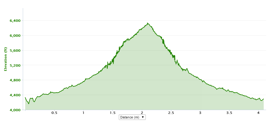
And a sample elevation profile:


Sunday, June 5, 2011

Ice Box Canyon - Red Rock, NV

Being one of the most popular and well-known hikes in Red Rock, we finally decided to try it out after living in Las Vegas for so long.  I think we put it off for awhile because it's a shorter hike, but now we consider it one of our favorites and can't wait to take visitors or just do it again ourselves.  It's popularity is evidenced by a very full parking lot in the middle of the day.  Good sign for us since we are such late starters and we didn't have to worry so much about the desert heat since so many others thought it was a fine time of day to hike.

The route starts off flat, somewhat boring, and without shade, but then you get to some more scrambling parts and that's when the fun started.  The scrambling was fun and we took our own route somewhat to get to the base of the waterfall.  Since it was June, the water wasn't flowing anymore.  It'd be nice to go back earlier in the season and see the actual waterfall.  We climbed up the last part to get to the base of where the water pools before falling down into the canyon.  A few people were climbing the walls of Ice Box Canyon, but we opted to sit next to the little puddle and enjoy a snack in the shade and cooler weather.

Getting down from our positions took much more maneuvering so that we didn't fall into the murky puddle.  That was fun.  Karen got into a bit of a pickle, but she made it out without falling into the dirty water.  We definitely took a picture of the route Phil took down, as it was somewhat dangerous and kind of crazy.  He decided to slide down the smooth rock that the water flows down in the earlier months of the year.  It looked like a good idea at the top, but he picked up a lot of speed and luckily landed on his feet with a running start.  Other onlookers thought he was nuts and looked about as worried as Karen as he flew down the smooth rock.  See the picture below.

Somehow, we got off track on our way back and ended up in thick desert brush trying to find our route.  We could obviously see the parking lot and weren't too worried about finding our way back, but Karen went on and on about rattle snakes in the brush.  We made it back to the parking lot with no such encounters and were happy with the hike.  It wasn't especially hard or long, but the cooler weather once in the canyon was a pleasant surprise and the making your own route, of course, always appeals to Phil.  We will definitely be doing this hike again, especially some time during the spring so we can catch the actual waterfall.


Precarious Climb Down


Yep, Phil slid down the middle of this.  It's steeper than it looks.


The GPX is not the best because we were in a canyon, but we will include it anyway.  
GPX Link: https://www.dropbox.com/s/v6udsk9u3i4gwm5/Icebox%20GPX.gpx

Saturday, May 28, 2011

Pineknot - Big Bear with C & A

The elevation calculation on this is not accurate from Garmin Connect, but the elevation image does seem accurate. The elevation gain was really 1818 ft. FYI that the GPX for this includes a detour as we got off course at one point. This hike is worth repeating.


GPX Link: https://www.dropbox.com/s/w1scmn2zwhfsjo8/Pine%20Knot%20GPX.gpx

Wednesday, May 18, 2011

Big Falls - Mt. Charleston, NV

Big Falls hike isn't the first hike people think of when hiking to a waterfall in Mt Charleston.  We had already done the more popular Mary Jane Falls a few times and decided to try out the this hike to get to Big Falls for something different.  The trail starts out at the same parking lot as the trail head for Mary Jane Falls.  The parking lot is the first on the left on Echo Road.  If you miss the turn and continue on Echo Road, you will end up at the parking area for Trail Canyon.  You actually start at the Mary Jane Falls trail head and make a turn towards the left when the Mary Jane trail curves to the right to start switchbacks to Mary Jane Falls.  It's not that clear on the trail where you turn off, but we used  http://www.birdandhike.com/Hike/Mt_Char/Big_Falls/_Big_Falls.htm  as a reference.  Mary Jane Falls is an official hike of Mt. Charleston, and Big Falls is not, which is probably why it's not super clear where to turn off the Mary Jane Falls trail.

We had researched this hike and it was described as having a lot of scrambling and being short, but fairly difficult.  We didn't experience much difficulty because of the time of year we went.  It was too early in the season and the snow hadn't hardly melted from the Big Falls trail so we had a fairly easy, but cold climb, as we ascended to the falls.  The reason we went so early in the year was that we wanted to make sure we caught the falls, as we know waterfalls in the desert are definitely seasonal.  The snow acted like a buffer between us and the debris we were supposed to be scrambling up so we made quick time up.  Poking through the snow blanket was a lot of tree debris and it looked as if an avalanche had occurred, although probably not true by any means.  Under the snow blanket, you would normally climb a canyon full of boulders and logs.

Phil and I hiked with a couple of friends and none of us were prepared for the amount of snow we encountered and we (especially the girls in their shorts and t-shirts) shivered up the mountain.  Once you get to the last steep hill, the snow was somewhat mushy and we picked up some walking sticks to hold our footing.  The actual falls were flowing and the mist coming off the falls was substantial enough to get damp and chilled when you walked up to it.  The falls were about 60 feet and pretty impressive.  We didn't stay long, however, due to the cold and lack of proper clothing.  In fact, the girls ate more than half their lunch on the way down. 

Also, the supposed distance is 2.8 miles round trip, but we ended up shorter, probably due to the snow making our route more direct.

This hike is a definite must do again, as we want to experience it when there isn't quite so much snow and we can do some more scrambling and go up to the actual falls and enjoy a nice picnic lunch.


Her lips are blue from the cold.

Phil pushing the limit and getting too close to the ice edge of the falls.


Saturday, May 14, 2011

Pine Creek Canyon - K and C

A quick hike in Red Rock with C.  I don't think we ever made it to our final destination as we got off course and ended up doing some bouldering and then turned back.  Total miles: 2.58

Friday, April 1, 2011

2010-2011 Snow Season Resorts

When a time comes that we are not living life we may write more about each resort, but for now here's a summary of our snowboarding season '10-'11:

March 2011
Brian Head
Brian Head
Brian Head
Las Vegas

April 2011
Las Vegas
Brian Head
Brighton
Brighton
Solitude

2011 was the start of our passion for the snow.  We were bit by the bug and have been riding powder ever since!

Sunday, October 17, 2010

Angel's Landing - P&K, Nikki, Alex, and C&A

A group of our very best friends all decided to camp in Zion.  It was a wonderful experience and can probably be credited with planting the seed that would become our love of tent camping.  We did the famous Angel's Landing hike.  Here are a few photos from the campsite and hike.